Nevada City, California
Hometown Summary
My partner Sam and I moved to Nevada City last March to work a season at an organic family farm. We were transitioning from farming in the North Bay of California, and decided to spend the winter in Bishop with the intention of improving our climbing skills. Instead, we ended up falling in love with trail running through our rest days on the dirt roads and trails around the Buttermilks. In our search for a place where we would be able to work in our job fields while maintaining this new addiction, Nevada City called to us as a friendly foothill town with great trails and easy access to the mountains.
Bordered by the Tahoe National Forest in the north and east, touching the canyon of the South Fork of the Yuba River, and bisected by Deer Creek, it is easy to find a run with whatever distance and terrain you are craving within a 20 minute drive of town, any day of the year. Meanwhile, an hour in either direction on Highway 20 takes you to the famous trails of the American River in Auburn (think Way too Cool 50k and the last miles of Western States 100) or the High Sierra mountain trails surrounding Lake Tahoe. Not to mention, the Bay Area is only a three hour drive west. With this access and our climate, there are racing opportunities nearly year round.
Nevada City is most well known as one of the most successful mining towns of the 1850s (it became the third largest city in California at the time, with over three times the current population), but I think it should now be known for its community’s commitment to environmental protection and stewardship. There are some incredible organizations including Sierra Streams Institute, South Yuba River Citizens League, and Bear-Yuba Land Trust working to protect our waterways, wildlife, and land while deeply engaging the community in stewardship and citizen science initiatives— if you’re interested, check them out for volunteer opportunities and fun events like SYRCL’s Wild & Scenic Film Festival in January. There is also an awesome organic farming community growing the best fruits and veggies around.
Despite being a popular weekend getaway spot for folks in the Bay Area, Nevada City is protected from development through historic preservation and retains every bit of its small town charm on busy weekends. Plus there are plenty of back roads, hidden trails, and secret swimming holes to escape the summer crowds.
Climate
The climate of Nevada City is similar to the Mediterranean climate type of the Bay Area but with more interesting edges as it lies mostly at 2,500 ft on the western slope of the Sierra Nevada range. The summers are warm and dry with cooler nights, and the winters are characterized by heavy rains, a negligible amount of snowfall, and an average low in the 30s and 40s. July and August are the driest and hottest months, sometimes reaching the high 90s and occasional 100+ days, necessitating trips to the Yuba and nearby alpine lakes while counting your blessings because you’re not in the Sacramento Valley where it can be 20 degrees hotter. It is very very unlikely you will get a drop of rain here between June and September, so you won’t need to pack a raincoat on your summer trips unless you are heading to the High Sierra at some point (where you may encounter afternoon thunderstorms). Especially with the ability to easily travel up or down the hill, comfortable training has been possible year round while living here. My advice: carry water on summer runs, use the icy river in the fall to soak the legs, and develop a good layering system for the winter!

Terrain
The diversity of trails in and around town allow you to decide where you want to run based on the type of terrain you want to encounter. The South Yuba River canyon trails are all single track (except for some connecting fire roads) with some technical sections. Running in, through, and out of the canyon is the best way to build elevation gain into runs without heading towards Auburn or Tahoe (see Round Mountain Trail). In contrast, the most accessible trails to town are well maintained, flat single and double track along irrigation ditch canals, perfect for speed workouts and easy after-work runs.
Where to Run (Trails!):
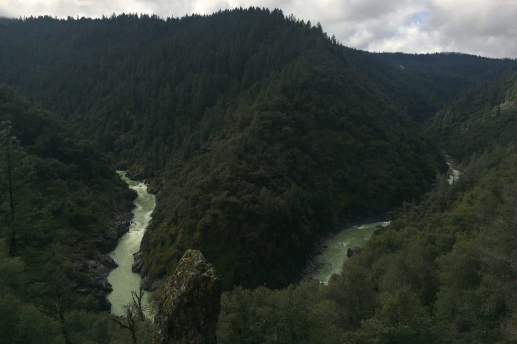
The South Yuba River Trail runs parallel to the South Fork of the Yuba River for 20 miles, rewarding you with incredible views of river bends and sections right along the river bank perfect for swimming breaks. There are several access points to this trail system from Nevada City, including Purdon Crossing, Edwards Crossing, the South Yuba Campground Trailhead, Malakoff Diggins, and from the town of Washington. My favorite access point from town is at Edwards Crossing, about a 20 minute drive, where you can run the 4.4 mile single track downstream to Purdon Crossing and back (one way has a 500 ft gain and 700+ ft loss). This trail also connects to the Round Mountain Trail, offering opportunity for vertical gain with 1000 ft in 2 miles of switchbacking trail to an incredible view at Coyote Overlook. If you are willing to run on stretches of dirt road, there are several opportunities for loops in this state park.

As a note for summer travelers, the crowds at these local river access points can be overwhelming and a parking nightmare on weekends after 10 am. Running from the South Yuba Campground Parking lot is the best way to avoid the chaos and find open space on the river. From the trail beginning (right of the pump house) it’s 4.7 miles down to the river, with the option to continue on the South Yuba Trail to Washington or on the technical climb on Humbug Trail up to Malakoff Diggins.

* A few tips: Drive safely on the road down to the river, it is narrow and windy with limited visibility on the bends. There is bathroom access at each trailhead (pit toilet or porta-potty), and remember, pack it in, pack it out. Posion oak LOVES this environment so watch out. And regardless of which trail and the distance you run, bring a picnic and snag a spot on the wild and scenic river for a perfect afternoon!
The Tribute Trail along Deer Creek was the first trail I encountered in Nevada City and has been the most convenient trail for my weekday runs and workouts. The area carries historical significance as the site of the two major gold mines of the late 1800s that put Nevada City on the map, the Champion Mine and Providence Mine. Evidence of the buildings, shafts, and stamp mills can be seen from both sides of the creek, and a trail to the Providence Mine is marked off the Environs loop on the south side of Deer Creek. The trail system can be accessed from downtown Nevada City if you don’t mind running on the road for about three-quarters of a mile, or from the Champion Road Trailhead, a quick 4 minute drive from town center. There are a couple directions you can go from here, my favorite being the Tribute Trail along the Newton Ditch Canal, and with the addition of a 0.4 mile side trip from this trail down to the Chinese Bridge at Stocking Flat and a 0.6 mile loop off the south end of this bridge, is a fast, mostly flat 6-8 mile run. There are also several more technical, single track trails to explore by crossing the Anqkula Seo Suspension Bridge to the south, with interpretive signs and access to the other side of Nevada City (see Deer Creek Environs Trail).
I recommend finishing a run on Deer Creek at Three Forks Bakery and Brewing Co., especially on Wednesdays and Thursday before 6 for a happy hour beer.
Ditch Trails: Cascade Canal
The Nevada Irrigation District manages irrigation canals through several parts of Nevada City, alongside which are service paths open to the public. The most accessible and continuous of these trails is the Cascade Canal Trail with 4.5 nearly level miles. At 3200 ft elevation, it is a cooler escape for summer runs in town, mostly shaded by some huge pines, douglas firs and dogwoods. If you want to work some hills in, try the Orene Wetherall Trail about .8 miles from the Gracie Road trailhead. Other ditch trails to explore (they tend to be on the DL, scanning Google Maps or my Strava will be the best way to find them) include the Cement Hill ditch trail, Banner Lava ditch trail, and I’m sure another I have yet to find.
Within an Hour Drive
Bowman Valley Road, Grouse Ridge
There are so many trails within an hours drive of Nevada City worth mentioning, this area being my favorite. A great spot for a quick weekend backpacking trip, for trad and sport climbing, for a run worthy of the day trip, or all three in magical combination. The highlights of this area are the many gorgeous alpine lakes. Starting from the Carr Lake/ Feely Lake, Lindsey Lake, or Grouse Ridge Lookout trailheads you can head all the way out to Glacier Lake, Five Lakes Basin, or turn around at the many lakes in between. Starting at an elevation of 7500 ft, the trail can be quite technical with a lot of steep elevation gain, but I promise you that the lakes make it worth it. This is the perfect spot to try out a weekend fastpacking trip! It’s inaccessible in the winter and early spring due to snow, so you’ll have the best luck here between July and October.

Auburn State Recreation Area and Cool, CA
Another nearby spot that’s obviously worth a mention is the Auburn State Recreation Area, home of the last miles of Western States 100. Whether you are training for this race, one of the incredible races put on by NorCal Ultras (Way too Cool, American River 50, Rio de Lago to name a few!), or not, these trails are serious fun. A popular loop that overlaps with some of the Way Too Cool 50k course is the 8.6 mile Olmstead Loop accessed from the trailhead behind the fire station in Cool, CA. Coming from Nevada City in the heat of the summer, it is hard to imagine traveling downhill where it is even hotter, but in the spring and fall, the trip is an easy season extender.
One of the perks of living in this area is plentiful opportunities to volunteer for these races— it’s magical and fun, I definitely recommend it! For other opportunities to connect with the community, join the Sierra Nevada Trail Runners.
Lake Tahoe Area
Obviously I can’t wrap this up without mentioning the endless trails of the Tahoe area. Check out the Pacific Crest Trail at I-80, Tahoe Rim Trail, Donner Lake Rim Trail, Rubicon Trail, Desolation Wilderness, Hole in the Ground Lollipop route, the Squaw Valley area, and so much more. The Donner Party Mountain Runners are an active running group in the area to check out as well. I highly recommend the breakfast burrito at Full Belly Deli and a beer from FiftyFifty Brewing Co. You may consider this out of bounds, but if you have more than a few days, continue south on Highway 395 to explore more of the Sierras— Tioga Pass, Lee Vining area, Mammoth Lakes, Bishop… Trust me, it’s worth it— I’ve gone all the way to Bishop for a weekend run and regretted not a moment of the 5 hour drive.
Where to Eat (Pre & Post Places to Eat & Drink):
Three Forks Bakery and Brewery
A great place to stop in Nevada City at any time of day, this spot named for the three forks of the local Yuba River as well as their three pronged business – bakery, brewery, and cafe. You’ll find incredible pastries in the morning, wood fired bread loaves after 11 am, creative sandwiches, salads and pizza full of local ingredients after 11:30 am, amazing beer, and chocolate cake. My favorite running fuel is the tortilla española and a cup of locally roasted coffee, and for recovery, the Oak Tree Pale Ale with olives and a farinata (a large pancake made of chickpea flour sprinkled with olive oil and rosemary).
Ike’s Quarter Cafe is hands down the best breakfast in town. It is a classic breakfast cafe with a New Orleans cajun twist, offering an extensive menu with plenty of vegetarian options. If it’s a nice day, opt to sit outside under their famous cherry tree. It gets super busy on the weekends so plan to get there early or wait!
Farmers Market: Musa Musa and Falafel
If you happen to be in town on a Saturday, June through November, stop at the farmer’s market in town between 8am and 1pm. There are great food vendors and always fresh snackable produce from caring, hardworking farmers. Some highlights from the 2016 season are falafel from Falafel Kis, tostones from Musa Musa, and sweet crunchy peppers from Riverhill Farm.
The Briar Patch produce is the freshest you will find at any store in the area and they have a huge selection of bulk goods, including great runners snacks and dehydrated products perfect for a camper’s lifestyle. They also have a great selection of holistic health products as well as some killer sandwiches in the deli (the Tempeh Reuben is king!).
Yoga Studios
You can hardly throw a stone without hitting a yoga studio around here. The Golden Mandala is a donation based yoga studio in town with a variety of classes, perfect for those cross-training or super rainy days. Other yoga studio schedules to check out include The Yoga Dive and Wild Mountain in Nevada City and Kinfolk in Grass Valley.
Where to Shop

Trkac (pronouced “TraKaCH” which means runner in Croatian) is our wonderful and only running store in the area. In a small space they’ve somehow packed everything you’ll be looking for, including a wide selection of shoes, fuel, clothing, accessories, and gear. Owners Leatrice and Mark are ultra-runners and very friendly— ask them about their team, nearby races, trail recommendations, for contact information on local running groups, and general advice. They will be very happy to help!
Wrap Up:
I acknowledge my bias as a native Californian, but this state has a truly special ecology and geology everyone should experience. Nevada City highlights everything I love about California with its supportive, environmentally-minded community, good food, and beautiful trails. The foothills are a wonderful place to live if you love the mountains but can’t quite commit to the high elevation lifestyle. And if your main sport is trail running, the weather allows you to get outside all year round— especially if you enjoy the occasional romping in the mud, winter warrior style.
Strava Segments
South Yuba Trail, Edwards to Washington
