Bozeman, Montana
Situated in a large valley in Southwestern Montana and surrounded by three mountain ranges, Bozeman is an outdoor mecca for any interest from fly-fishing, to kayaking, to backcountry skiing. The area also holds renowned trails and trail races. Currently, Bozeman has a boom town feel, as the population has increased from 38,000 to around 45,000 in the last six years. Bozeman is also home to Montana State University. With a tag line of “Mountains and Minds,” MSU contributes a transient student population of about 16,000 during the academic year. Bozemanites are grateful for two amazing ski areas, Bridger Bowl and Big Sky. In addition, there are three rivers that provide year round world class fly fishing: the Madison, Gallatin, and Yellowstone and at times of the year kayaking and rafting opportunities. Bozeman boasts a large tourist population in the summer months; as their primarily draw is visiting Yellowstone National Park, which is a 90 minute drive. I have lived in the valley on and off for six years over the last ten years. I moved back in 2015 and am here to stay, mostly because of the recreational opportunities. I will cover some of my favorite trails in the area, but keep some special spots a secret. Be aware this is the Northern Rockies territory, as grizzly bears are found in almost all mountain ranges, as are black bears, and some mountain lions. Travel with a friend (ideally) and with bear spray.
Recreational Areas
Bridger Mountains
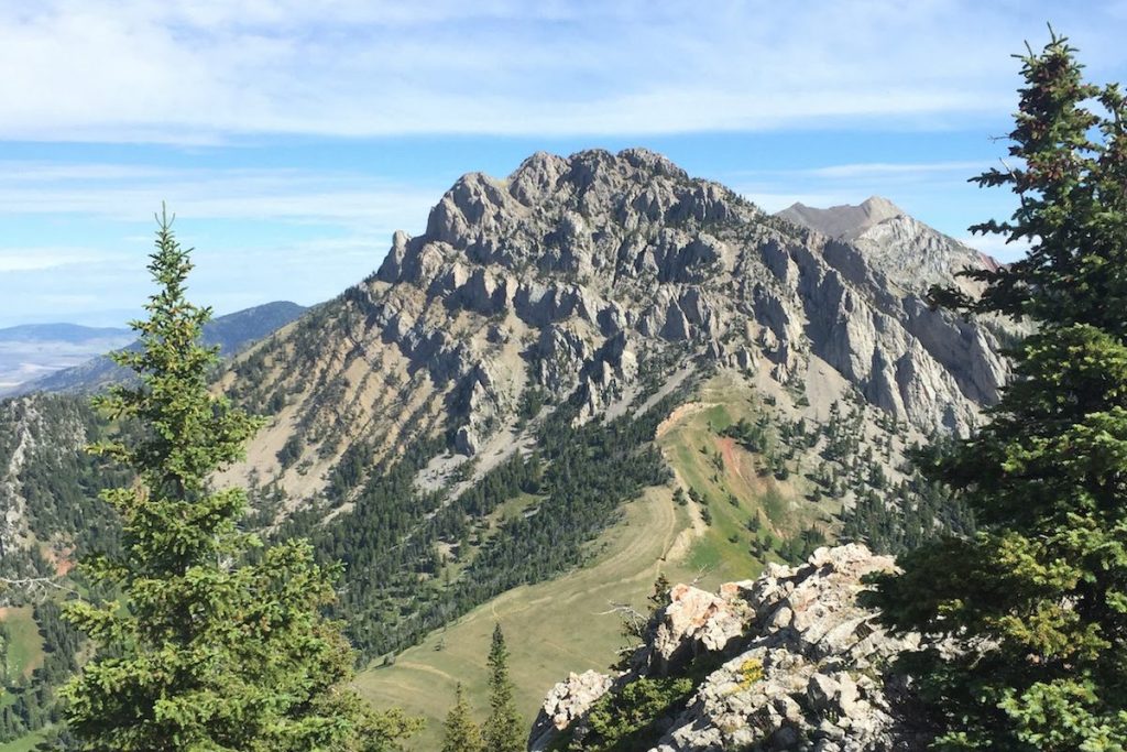
The Bridger Mountains are easily accessible from town and perfect for anything from a quick after work jaunt to a full day adventure. The Bridgers run approximately northeast from Bozeman and have access points on both the west and east sides.
West:
The most trafficked and easily accessible trail from Bozeman is the “College-M” trail. Heading for the top you have two choices from the bottom, the “hard way” or the “easy way.” No matter which direction you go, you gain a quick 850 feet of elevation either over .5 miles or 1.5 miles. The M provides a quick training location for laps before or after work, with a typical route being up the hard side and down the easy side for as many times as you can. Continuing on past the M you can suffer your way on to the top of Mt. Baldy for a significant, but easy access training day. The trail goes 4-4.5 miles (depending which way you went up the M) and over 4,300 feet of elevation gain. Sunrise and or sunset runs to Mt. Baldy in the summer are a Bozeman rite of passage. You can decide if going up or down is harder; for me, I change my mind twice every time I go up there.

There are numerous other trailheads on the west side of the Bridgers decreasing in popularity and traffic as you head north. Sypes Canyon is the next trailhead you hit along the west side of the Bridgers. The four mile loop to the top provides 1,000 feet of elevation gain and a great view of the valley. This trail connects via the Foothills trail to the M trailhead and can provide a nice 7 mile one way shuttle or a pretty brutal but simple logistical day with a total of 14 miles and 4,000 feet of elevation gain. The trails continue to the northern end of the Bridgers and end at Johnson Creek trailhead.

East:
The east side of the Bridgers provide significant opportunities for long treks with the appropriate planning and shuttle systems. The most common connector is also run during the Bridger Ridge Run. You can do it any other day of the summer (July to Mid-September) on your own, but be warned there is no water! You start by bumping and jumping up the Fairy Lake Road for five miles until you hit a trailhead that can be busy in the summer. You head towards Sacajawea Peak on the Fairy Lake Trail. Climbing steadily to a beautiful mountain cirque, then begin to switchback up the walls of the cirque to reach the ridgeline.
Another few switchbacks and you are on top of Sacajawea. Though out of breath, you will feel accomplished and great! Now, you can run another 16-17 miles and gain 4,000 feet more of elevation, and lose 11,000 feet! This next part of either the race or the day can be tricky, you lose elevation (to skirt around the rocky Ross peak) and can run hard over a flat forested trail to Ross pass. Be wary! This is still the first 1/3 of your day, try to conserve energy and fight the urge to run your heart out. The first aid station or break point is at Ross Pass, the trail then almost unconscionably drives you back up the ridge to Bridger Bowl. For me, a very average trail runner, this is a highly difficult section.
Once you get to Bridger Bowl, on race day, there is a large crowd of fans and a huge aid station. This is a great place to take five minutes. Commonly when people train for the Ridge Run, the Sacajawea to Bridger Bowl is a great section to run one weekend and then Bridger Bowl to the M as another section. Bridger Bowl to the M is the epitome of mountain running. You are at 9,000 feet almost the entire way until you hit Mt. Baldy and moving quickly over some rough running terrain. You reach Mt. Baldy and you are only 4 miles to the end, but you still have 4,000 feet of elevation to lose. The last section is tough, and is why I run. Bounding down steep, rocky and sometimes hard to find trails is thrilling. You reach the M trailhead where hopefully you have shuttled a car or someone who loves you dearly is willing to pick you up. You have run 19-20 miles (depending how you come down the M), gained 6,000 feet of elevation, and lost 11,000 feet of elevation. Racing, running, or hiking the Bridger Ridge from Sacajawea to the M is a difficult but great way to spend a day. Be careful with dogg0s, as the rocks on the ridge are particularly tough on pads and there is no water. I have heard of people having to carry their dogs off the ridge.

Gallatin Range:
Easily accessed on the North side from Hyalite canyon or the West down Gallatin Canyon road. There are endless ways to connect trails for long, wild days or quick jaunts up and back.
North End:
Hyalite Canyon is truly a blessing. Close to Bozeman, there can be lots of traffic heading up the canyon, particularly on warm summer days. There are five primary trailheads in Hyalite; they range from handicapped accessible Palisade Falls to Blackmore Peak. Blackmore Peak is a 12 mile round trip with 3800 feet of elevation gain. This trail provides the user with long, forested portions, cirque switchbacks, and unbelievable views. Blackmore peak is a Bozeman classic.

West End:
Driving down Gallatin Canyon road south from Bozeman there are limitless trails both on the east side of the road (Gallatin Range) and west side of the road (Madison Range).
Storm Castle provides a quick, steep hike with great views and easy access. Another Bozeman classic.
Garnet Mountain is another quick, steep hike that also has an old fire lookout.
Madisons
From Spanish Peaks road you can access the Spanish peak trailhead that provides several different trails with out and back or shuttle options.
From Gallatin Canyon Road you can access part of the large Madison range. One shuttle that connects Spanish Creek trailhead to the Gallatin Canyon trails is Bear Basin near Big Sky to Spanish Creek trailhead. This shuttle is around 18 miles and takes you from large, glaciated high elevation mountains meadows, past a world class fishing spot (Mirror Lake) through low gently forested trails. This is highly recommended and a relatively easy car swap.

Eats, Drinks and Shops
The food scene in Bozeman is fabulous. As a mom who usually sneaks out early to run, if I grab food, it’s on the way home and it’s usually something fast and healthy. One of my favorite fast casual restaurants here is Lot G. Their tag line is “healthy food for all,” and they mean it! You can get breakfast or lunch from 7-3 pm every day. Two of my favorites are the hoisin noodle bowl and the huevos. Another fast, but healthy option is Five on Black. Brazilian made to order bowls that can be adapted for gluten free and vegetarian. Also, just go ahead and get the bakers dozen of the cheese rolls!
Our breweries are numerous, delicious and offer great food options. A local favorite is Map Brewing. Located near the East Gallatin Recreation Area, it has an amazing view of the Bridgers, delicious beer and food. Additionally, there is a huge outdoor area friendly for doggos or kiddos.
The local running shop, Bozeman Running Company, is the favorite shop for running gear. The staff is super knowledgeable on all their inventory and will spend a significant amount of time with you to find the right shoe or other gear.
Conclusion
This is a 10,000 foot fly-by of the world class running available in and around Bozeman, MT. Other areas to explore if you don’t mind the drive include: the Absaroka-Beartooth Range, Yellowstone National Park, Tobacco Roots, and numerous renowned races, the Rut Mountain Runs to name one!
Bozeman has quite literally a lifetime of trails to explore in the surrounding areas, which is what I plan on doing during my life!





One Response
Hey Allison, great blog!