I am no mountain runner, nor do I pretend to be. Yet, I am constantly humbled by mountains and find myself wandering through them, eager to know them, whenever I am able. There is a vastness and wildness among them that I long to understand. For me, they are other-worldly and larger-than-life.
The Village of Saranac Lake in New York hosts the Saranac Lake 6er Program, in which the goal is to summit six mountains. From smallest to largest, these include: Baker Mountain, St. Regis Mountain, Scarface Mountain, Ampersand Mountain, Haystack Mountain, and McKenzie Mountain. Once a hiker or runner has summited all six peaks, they are permitted to ring the 6er bell located in the Berkeley Green and register to receive the official 6er patch, as well as a signed certificate of completion. My sister-in-law Chenelle would be the first to tell me about the program, and she was there with me when I completed my first summit.
Baker Mountain: first summit on 8/25/14 (my 1/6)
I first summited Baker Mountain almost a decade ago, when I was visiting my in-laws one August and Chenelle suggested we try out a Zumba class. I was much too uncoordinated for the aerobics boom back in the 1980s and 1990s, but wanting to spend time with her, I agreed to give Zumba a shot. Well as fate would have it, the Zumba class was canceled, and so she suggested a casual hike up Baker Mountain. And off we went, Chenelle in her flip flops and I barefoot, and this is how we both summited that day. (Note: We were both experienced in traveling on foot this way and I would not recommend this to anyone else.) It was such a beautiful hike and amazing experience to reach that first summit (even if it’s the smallest of the Adirondack peaks). Since that morning, I have returned to Baker Mountain numerous times, summiting the mountain in both winter and summer.
According to the Village of Saranac Lake:
Distance to the summit: 0.9 mile one way
Elevation gain: 884 ft
Peak elevation: 2,452 ft
Ampersand Mountain: first summit on 7/2/16 (my 2/6)
After my first summit of Baker Mountain with Chenelle, and in spite of multiple visits to Saranac Lake, it would be almost two years before I summited my next mountain in the Adirondacks. By this time, I had learned of the Saranac Lake 6er program but I wasn’t yet convinced that I should make the time for myself to accomplish such a goal. Yet on this day I would complete my second summit, and would do so with two of my sisters-in-law Chenelle and Chelley, and my mother-in-law Dawne.
It was a beautiful and calm mountain morning as we signed the registry and began our journey onto the Ampersand Mountain trail. We were greeted by beautiful old-growth forests of sugar maple, beech, hemlock, and yellow birch, some of which are hundreds of years old. The early morning weather was cool, which made hiking a little easier. I loved listening to the songs of new-to-me birds as we talked about so many things and had a few laughs. A few hours later, we arrived at the final climb to the summit, and after some hand-over-fisting, we reached the summit. Rather unexpectedly, we were greeted by a sudden 30°F drop in temperature and gusting winds that made it difficult to stand up or hear each other. And we were in the clouds, so there would be no views for us on this day. Still, we were able to take in the summit for what it was without a view, have a few laughs, and celebrate being there before beginning our descent. It was a great way to spend a summer morning.
According to the Village of Saranac Lake:
Distance to the summit: 2.7 miles one way
Elevation gain: 1,755 ft
Peak elevation: 3,353 ft
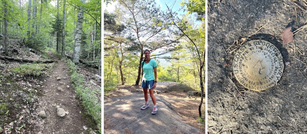
Scarface Mountain: first summit on 7/2/23 (my 3/6)
Last summer, after weeks of questionable air quality and a successful Baker Mountain quadruple summit the day before (described below), I awoke once more in Saranac Lake to good air quality and a change in the weather forecast to no rain. I made the decision that I would get myself at least halfway to becoming a 6er before leaving town. And on this day, I would explore Scarface Mountain. The idea of reaching even 3/6 in my goal sounded amazing, having been stuck at 2/6 since 2016. So I leapt out of bed, got dressed, ate a banana, and headed out the door. It was only a short drive and soon after arriving, another car with three hikers from Ontario, Canada parked next to me. They had summited St. Regis Mountain the day before and provided a few updates on the trail conditions there, while they graciously shared their bug spray (the one thing I managed to forget). After a few minutes of friendly conversation, we parted ways and I began running.
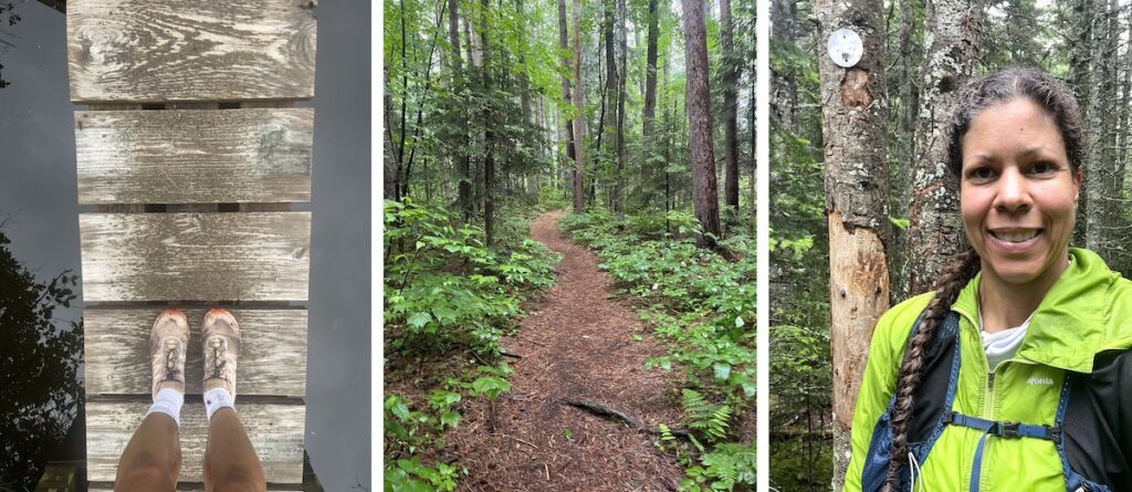
Within minutes, I was greeted by beautiful old growth evergreen trees, whose needles blanketed the trails and forest floor. I could smell all the evergreen all around me, and being present here was a treat for all my senses. Crossing the bog, I was able to walk on the boardwalk my father-in-law John had built for the trail many years ago. After taking a photo of the bog and the boardwalk, I was again running under a canopy of evergreens towering above me and as I traveled underneath, I became so immersed in my thoughts that I managed to miss a very obvious left turn, one that included a large and prominent arrow on a tree marked “TRAIL.” I even managed to jump over the logs placed over the trail at the junction to encourage everyone to turn left! After 30 minutes of circling, exiting the woods to a cow pasture, and consulting both the AllTrails and Apple Maps apps, I popped back out onto the correct trail. But as I began to recognize landmarks that I had already passed, I realized that I was now headed back in the direction from which I originally came, toward the parking lot! So I turned around once more and, after a few minutes, came upon the very obvious turn, the one that included a large arrow on a tree marked “TRAIL,” as well as the logs that I had originally jumped over. This time I turned in the direction of the arrow, and after a few more minutes of cruising, I began my climb.
Following a rockier section, the trail steepened significantly, requiring more hand-over-fist scrambling. But this soon gave way once more to runnable trails, and not far from the summit I crossed paths with the hikers I had met at the trailhead. They had been concerned when they reached the summit but hadn’t seen me. They noticed that I had also failed to sign the registry. This would be a valuable lesson for me. Note: if you run or hike any of these mountains and fail to return, the New York Department of Environmental Conservation (NYDEC) will not know your information and whereabouts if you haven’t signed the trail registry. So I signed it on the way out and would sign registries for all remaining mountains I would climb on this visit. After explaining my wrong turn, we had a few laughs. I thanked them for their concern and for watching out for me, and then continued to the summit which was just a few minutes away.
As for the summit…it’s literally in the trees. Regardless of weather, there are no views to witness, other than forest and the metal tag that confirms your arrival there. But, for me it has always been about the journey and successfully reaching the summit. I was now halfway to becoming a 6er and it was great to stare at the trees for a bit and just be present there for a while, before beginning my descent. After backtracking and making my way back to pine-needle-blanketed ground, I resumed running, and ran all the way back to my car.
I would summit Scarface Mountain (7/2/23) exactly seven years after I first summited Ampersand Mountain (7/2/16).
According to the Village of Saranac Lake:
Distance to the summit: 3.8 miles one way
Elevation gain: 1,480 ft
Peak elevation: 3,088 ft
Haystack Mountain: first summit on 7/3/23 (my 4/6)
Monday morning felt a bit like groundhog day. Once again I awoke right before my alarm to find an improved weather forecast and air quality, so once again I leapt out of bed, got dressed, and headed out the door! On this day I would summit Haystack Mountain. After another short drive, I arrived at the trailhead and discovered two cars already there. I’d eventually encounter this party of four near the summit and on my way back down the mountain. I was absolutely elated to be there; I’d lost track of how many times I’d driven past this trailhead on Route 86, only to be headed somewhere else, anywhere else, and anywhere but here. I would always dream of the day when I’d finally see these trails and bag this peak! I signed the registry and started running, and while I did run along the flatter first couple of miles, there was some rock hopping and log crossing to avoid the muddiest of mud patches. As I climbed in elevation, I really began to feel the magnitude of this mountain, compared to Baker and Scarface. I felt immense respect for this land and for this mountain, and was grateful to be here on legs that were strong enough to carry me. The last mile or so gradually evolved into a slow hike, with hand-over-fist climbing and a few extra breaks to catch my breath, as I approached the summit. Each time I paused, I’d take in the scenery and compare it to the trails I run on a daily basis, and this place seemed otherworldly to me.
As I approached the summit area, I encountered the four hikers whose cars I had seen in the parking lot, and we exchanged pleasantries as they assured me I was close. After a brief conversation, I reached the summit. Again there were no views, as the mountain was surrounded by clouds that morning. But how amazing it was to be there anyway! I wandered around for a few minutes, looking for the GPS marker. Unfortunately, I was unable to locate the marker and after taking a few photos, I began my descent. While I could descend much faster than I ascended, the first part of the descent was very technical and at one point I managed to slide just a bit, crashing my left kneecap into a boulder. Thankfully, other than some mild bruising, my knee would be fine. Not long after, I encountered the four hikers again, and the five of us hiked together for a short time, exchanging stories and backgrounds. Like me, one of the couples was in town visiting in-laws, who live near Ampersand Mountain. And they frequent Ampersand as much as I do Baker when in town. After several minutes, I bid them farewell and resumed running down the mountain.
According to the Village of Saranac Lake:
Distance to the summit: 3.3 miles one way
Elevation gain: 1,240 ft
Peak elevation: 2,864 ft
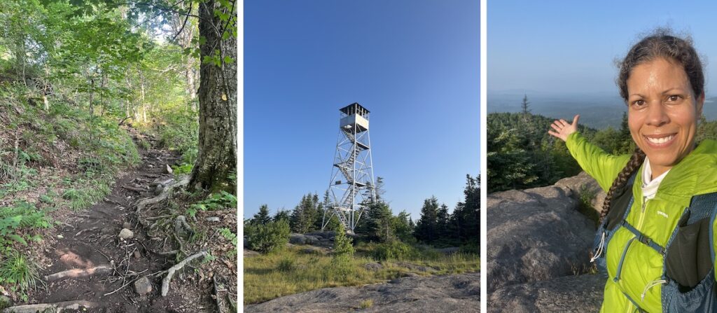
St. Regis Mountain: first summit on 7/5/23 (my 5/6)
With a rest day on Tuesday, I wondered if I could get one last summit done and leave town on Wednesday with my goal at 5/6. So on Wednesday morning, my alarm clock would sound even earlier, at 5:00 am. The skies were clear and the air quality was good. I got dressed, ate a banana, and drove to the trailhead. Wasting no time (also because the deer flies were abundant), I was able to begin my run up the mountain at 5:55 am (I would pause to sign the registry). The whole of St. Regis Mountain was more runnable than Haystack, though somewhat muddier. In fact, my sister-in-law Cherise has described rainy conditions on the mountain, in which the trail on St. Regis becomes a small river. I listened to the birds sing and studied the slight variations in terrain here compared to the other mountains, as I ran. The later sections of trail approaching the summit involved hiking over boulders. I was in such a rush, however, that I forgot to notice the trees more. Soon after traversing the boulder section, I reached the summit, and though I had originally been in a rush, I decided to take a few minutes to wander the summit area. And on this day, there were views! I was able to find the GPS marker, take a few photos of the surrounding peaks, and even climb up the fire tower. When I finally felt as though I had immersed myself in the experience as much as I could, I felt ready to begin my descent back to the trailhead. After passing back through the bouldery section, I began to run…I knew I was now at 5/6 in my goal of becoming a SL 6er, and the remaining miles clicked by as I felt nothing but euphoria and pure abandon.
Just one more left.
According to the Village of Saranac Lake:
Distance to the summit: 3.3 miles one way
Elevation gain: 1,266 ft
Peak elevation: 2,874 ft
Mckenzie Mountain: first summit tbd (will be my 6/6)
Unfortunately, I had run out of time to summit Mckenzie Mountain and would have to save that adventure for another day. Knowing I would be short on time to complete a 6th summit, I opted to save McKenzie Mountain for my last summit because it’s the largest of the six, with the longest approach. During my recent visit to Saranac Lake (described below), I was able to map out a route from the house and explore some of the connector trails nearby, so when I return, I’ll be able to run to the summit directly from the house. I’ll extend my approach a bit by running the Adirondack Mountain Trail first, and then continue until I reach a series of singletrack trails traversing the Saranac Lakes Wild Forest area. These trails soon converge into one trail under an old growth evergreen canopy and it’s absolutely beautiful there. This singletrack continues for just under a mile, until it reaches McKenzie Pond Road. Traveling south a short distance along McKenzie Pond Road, I’ll soon reach the trailhead for the Jackrabbit Trail, which continues all the way to the Mckenzie Mountain summit.
Somewhat eager to finally complete my sixth summit, I had considered heading up McKenzie Mountain when I was back in town. However, the Adirondack Mountains had not been immune to all the rain and warm temperatures (and mud) plaguing much of the Northeast for the past several months, and reports of trail conditions all repeatedly emphasized the significant amount of mud present. Not wanting to add hours to a potentially miserable mud slog, nor wanting to chew up the trails even more, I made the decision to wait. Perhaps later this summer or next winter will be better.
According to the Village of Saranac Lake:
Distance to the summit: 5.3 miles one way
Elevation gain: 2,221 ft
Peak elevation: 3,822 ft
Baker Mountain: more summer and winter summits
For the past couple of years now, I have run up Baker Mountain every time I’m in town visiting my in-laws, whether that’s in the summer or in the winter, and whether the trails are bare or covered in snow. I love being there so much that sometimes I even run up and down the mountain several times in a row.
Last July, when I arrived in Saranac Lake, I was feeling particularly restless after weeks of poor air quality in New York resulting from the wildfires burning in Canada. On several occasions, the smoke hung so thick in the air that you could begin to taste it. Not surprisingly, these conditions made it challenging to venture outside some days and complete my workouts. There had been additional rest days, rearranging of training days, and running with a KN95 face mask (though that came off on my first hilly ascent).
In the preceding weeks, I had begun to reconsider my prospect of becoming a Saranac Lake 6er and I had considered exploring a new mountain upon my arrival. I found myself struggling to remember why I would continue to put it off. When my girls were young, stealing away and leaving my husband to fly solo as I climbed mountains alone remained far from my mind. And motivating them to join me remained even farther. But now my girls are older and sleep in longer, and summer means earlier sunrises. And here I was in the Adirondacks, surrounded by mountains, on legs that were stronger than they had ever been, thanks to spring races like the Hyner Trail Challenge, Breakneck Point Marathon, and Cayuga Trails. I began to wonder what was holding me back from getting an early start and beginning my day with a new adventure. As it turns out, the answer was me.
Life is too short to always make excuses.
Still, I remained apprehensive about potential changing air quality.
So I left the house that first morning and summited the mountain I knew best – Baker Mountain. But as I ran back down, those weeks of stir-crazy suddenly came over me, and on that morning I would summit the mountain FOUR times. Including about a mile to and from the house, that would be good for 10 miles and 3,740 ft. of elevation gain. I just wanted to stay there longer. The weather was perfect. And the mountain was beautiful. I was absolutely fired up. First I ran up the more technical and rock-scrambly right fork in the trail, which I now know best. When I came back down I decided to go up the left fork, the more runnable side, which is what Chenelle and I hiked all those years ago. Afterwards, telling myself I was done, I left the mountain and looped around Moody Pond, but then decided I was, indeed, not ready to be done. So I once again ran up and around the mountain, only to do it once more after that. When I finally felt satisfied (as did my quads), I headed for home. While the Baker Mountain trails offer a few small boulders along the way, much of the trail on the more technical side (right fork) is reminiscent of the Breakneck Point Marathon course, and so it felt even more familiar to me. Along the less technical route (left fork), trails are more reminiscent of Finger Lakes trails, with fewer rocks and hand-over-fist terrain, but plenty of roots to run over. By the end of my run, I had seen the mountain from multiple perspectives and could call myself a Baker 6er…I had completed a “Baker’s half dozen”!
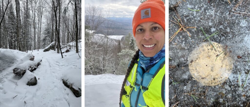
I completed my first winter summit of Baker Mountain in December 2021 and summiting solo for the first time in winter conditions changed me. I was nervous at first, giving myself permission to turn back if at any point, I wasn’t confident in my footing or the trail became too difficult to follow. I carried my microspikes in my hand as I ran from the house to the trailhead, and upon reaching the trailhead, paused my watch so that I could attach the microspikes to my shoes (I wear Kahtoola exospikes today but back then I wore YakTrax, which worked well for this hike). I then ventured onto the trail and into the woods. For me, there was no need to attempt a run, and so I was content to hike the entire way up to the summit. Previous hikers had worn down the trail and left behind their footprints, so along with the trail markers, the trail was relatively easy to follow. On this day, I opted for the left fork and would follow the less technical trail up to the summit, though both trails significantly steepen as you approach the summit. Being somewhat inexperienced at the time, this meant holding onto a few trees when I ultimately began my initial descent. Reaching the summit that morning, my confidence grew in leaps and bounds. Though I knew I still had to successfully get off the mountain, I was there and I had made it to the top and that was all that mattered for me at that moment. Gone were the days when I was once afraid to circle the lower trails around the pond near home alone. I could now summit a mountain in winter conditions all on my own, even if it was a small mountain. For my own benefit and experience, I have returned and summited Baker Mountain the past two winters and plan to continue.
Return to Scarface Mountain and Adventure Run
On my last visit to town, after running up Baker Mountain on the first morning, I decided to run the Adirondack Mountain Trail to the Scarface Mountain trailhead on the second morning. The goal was to explore some of the lower trails on the mountain for a while, before returning to the house. I love adventure runs and I love exploring new-to-me places. So I set out along the ADK Rail Trail and what was rain-covered the previous morning, was now covered in a light blanket of snow. I continued to run to the trail junction after crossing Route 86, but discovered that the Scarface Mountain trail was closed in early December because the NYDEC determined the main bridge to be structurally unsafe. It felt surreal because all seemed so well when I was last here in July. So I spent a little time exploring the lower trails and running down to the parking area (these areas remain open). It was neat to be back, even if I didn’t see all the trail sections I had hoped to, and I’ll simply have to plan to return another day. I then ran the rail trail back in the direction from which I came and after crossing back over Route 86, I explored the singletrack trails that connect to the Jackrabbit Trail heading up Mckenzie Mountain. Ultimately, it would be almost 13 miles of exploring that morning, and my heart was full.
Tips on Solo Adventuring
To be fair, the mountains I’ve explored solo to date are small, with relatively short approaches. I leave the house with a hydration pack carrying Tailwind, a snack, a rain jacket, identification, a few first aid supplies, and my phone. In the future, should I begin exploring larger, more remote mountain peaks, I may enlist a friend to come along and share in some of the adventures. That said, here are a few recommendations I can make regarding solo endeavors.
- Check the weather before heading out – mountain weather can be unpredictable and change quickly.
- Choose a well-marked and well-trafficked trail.
- Let someone know where you’re going.
- Let someone know when you’ll depart
- Let someone know when to expect you back.
- Know your limits and select a trail below your pay grade.
- Stay on the trail.
- Trust your gut regarding all things, whether it be other hikers or the weather.
- Know which wildlife you could encounter and know how you’ll respond.
- Don’t wear headphones.
Regarding headphones, a few months ago I was running my home trails and came upon a solo female hiker. I called out, “On your left!” but she didn’t respond. I called it out a second time, then a third time, and finally squeezed past her. Unfortunately, she became quite startled but it was a valuable lesson. I could have been anyone coming up behind her. Especially if you are a woman – I don’t recommend wearing headphones when running or hiking alone on the trails but if you must, consider leaving one earbud out so you can remain aware of your surroundings.
Benefits of Solo Adventuring
Running or hiking with friends is a great way to spend your time, but there are several benefits to running or hiking solo. In fact, you may be surprised to know that you may not end up completely alone. I have solo run and hiked countless trails in multiple states, only to find myself sharing the trail for awhile with a new friend, or engaging in friendly conversation with another party or couple. In my experience, most often those who you encounter will be just as happy to be on the trail as you are, and many are easy to engage in conversation as a result. In addition to good conversations, I have discovered several other benefits to solo adventuring.
- You can run or hike at your own pace.
- You don’t need to find a friend who can come along.
- You have to depend on yourself, so you learn new skills.
- It forces you out of your comfort zone.
- As a result, you’ll become more confident and more experienced.
Recommended Gear
For longer approaches, you’ll want to carry more gear in case of emergency and sudden changes in weather. Depending on how long your run or hike will be, you may consider carrying some or all of the following:
- first-aid kit
- personal identification
- warm layers
- lightweight rain jacket
- change of socks
- emergency blanket
- emergency whistle
- portable phone charger
- headlamp
- lunch/snacks
- water and/or electrolyte drinks
- microspikes, snowshoes, or crampons during winter conditions
- topographic map of the area
- GPS watch
- Garmin InReach
Final Thoughts
Between a recent muddy winter visit and a summer that is Western States, a date to summit Mckenzie Mountain remains somewhat elusive for the time being. But it’s exciting to be this close to finishing, when seven years elapsed between my first and second summits. That said, I can also recall a time when I was afraid to run any trails anywhere solo, so even though I may need to wait just a little bit longer to complete this goal, I know I’ll have the experience and the confidence to do so when the time finally comes.
References
https://saranaclakeny.gov/index.php?section=playing-hiking-challenge